Scenic Flights and Paragliding Over Crete
What do you actually see flying over Crete?
A tandem paragliding flight shows the fold of the White Mountains and the drop from the high ground toward the coast, not a single postcard peak. Psiloritis reaches 2,456 m, Pachnes in the Lefka Ori 2,453 m, and the Dikti above the Lasithi plateau 2,148 m, and all three can still carry snow into May or June.
The relief you actually fly over
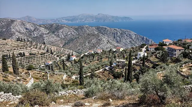
Crete looks flat on a map of Greece, a long thin shape stretched between two seas. From the ground, or better, from the air, it reads differently: a spine of high, folded limestone running almost the full 260 km of the island, broken by gorges that cut straight down to sea level in a few kilometres. A paragliding launch or a scenic flight does not show you one mountain. It shows you that spine, and the way the land drops from over 2,000 m to the coast in a handful of switchbacks.
Three ranges do most of the work. In the west, the Lefka Ori, the White Mountains, rise in a dense knot of grey-white peaks above Chania and the Samaria gorge; their highest point, Pachnes, reaches 2,453 m. In the centre, Psiloritis, also known as Mount Ida, stands alone above the plain and the vineyards, at 2,456 m the highest point on the whole island.
In the east, above the Lasithi plateau, the Dikti range tops out at 2,148 m, lower than the other two but still holding snow well into spring. A flight that shows all three in one sweep does not exist as a single fixed route, but a launch from anywhere on the north coast puts one or two of them in view within minutes.
What makes the relief worth seeing from above, rather than only from a trailhead, is the contrast. The Lefka Ori and Psiloritis are not smooth cones; they are folded, scarred by gorges, and often still carrying old snow patches in May while the coast below is already hot enough for a swim. That gap between the white ridge line and the blue sea, sometimes within the same photograph, is the single most distinctive thing about flying over this island rather than a flatter one.
Three high points, one shared fact: no lift up
| Range | High point | Elevation | Nearest region |
|---|---|---|---|
| Lefka Ori (White Mountains) | Pachnes | 2,453 m | Chania, above the Samaria gorge |
| Psiloritis (Mount Ida) | Psiloritis summit | 2,456 m | Rethymno / Heraklion border, above Anogia |
| Dikti | Dikti summit | 2,148 m | Lasithi, above the Lasithi plateau |
All three hold snow into May, and in a heavier winter into June, which surprises visitors who arrive expecting a Mediterranean island with nothing above beach level. What they do not have, and will not get, is any mechanical way up. Crete has no cable car, no chairlift, no funicular and no ski lift anywhere on the island, despite the snow.
The Psiloritis summit hike and the routes across Pachnes and the White Mountains are walked, in full, on foot, usually as long single-day routes with an early start. The Dikteon cave, the mythical birthplace of Zeus tucked into the Dikti’s lower slopes above the Lasithi plateau, is reached by a short paved path and then a steep, slippery, unassisted descent into the cave itself.
That absence of any lift is exactly why a paragliding flight or a scenic flight matters here in a way it might not on an island with an easier way up. It is one of the only ways to see the shape of these ranges from above without a full day of mountain walking, and the only way to see the drop from ridge to coastline as a single continuous view rather than a series of trailhead photographs.
Airports: three real options, one that is not open yet
Any flight-based trip in Crete starts at one of the island’s working airports, and it is worth being precise about which ones actually operate.
| Airport | Code | Location | Status |
|---|---|---|---|
| Heraklion | HER | Heraklion, north-central coast | Main international gateway |
| Chania | CHQ | Souda, near Chania town | Second gateway, closest to the Lefka Ori |
| Sitia | JSH | Far east, near Sitia | Small, limited scheduled and seasonal traffic |
| Kastelli | — | North coast, west of Heraklion | Under construction, not open to traffic |
Heraklion (HER) and Chania (CHQ) carry the large majority of scheduled and charter flights and both sit within easy reach of the relief described above: Chania for the Lefka Ori, Heraklion for Psiloritis and the approach to the Dikti and the Lasithi plateau. The Heraklion airport guide and the Chania airport guide cover the practical side of arriving at each. Sitia (JSH) is real but small, serving the far east with a limited timetable rather than a full international schedule.
Kastelli, the long-planned new airport on the north coast west of Heraklion, is not part of that list. It remains under construction, and it is not possible to land there today, whatever a search result or an older article might imply. Any current itinerary, air-based or otherwise, has to route through Heraklion, Chania or, for the east, Sitia. For anyone arriving by sea instead, the ferries from Piraeus to Crete run overnight to Heraklion and Chania, and the fuller getting to Crete flights and ferries guide lays out both options side by side.
When the sky actually cooperates
Wind, not temperature, is the variable that decides whether a paragliding flight happens on a given day. Crete’s summer brings the meltemi, a strong, sustained wind out of the north that is well known for cancelling the boat trips to Balos and Gramvousa and to Chrissi island; it has the same grounding effect on flights that depend on stable air. July and August are the meltemi’s strongest months, and they are also the hottest, with midday temperatures regularly in the 30-35°C range. That combination, heat plus unpredictable wind, makes high summer the least reliable window for anything airborne, whatever the calendar promises.
The better windows sit either side of it. Late April through June and September into mid-October both offer calmer, more consistent conditions: the meltemi has not yet built to its summer intensity, or has eased off, and the heat is manageable rather than punishing.
These are also, not coincidentally, the same windows recommended for hiking the gorges and for most outdoor activity across the island; the best time to visit Crete guide and the month-by-month breakdown in Crete weather month by month go into more detail on temperature and crowd levels across the full season. The dedicated page on Crete in July and the meltemi is worth reading specifically if a flight, a boat trip, or any wind-sensitive activity is the point of the visit.
None of this amounts to a guarantee. No operator, and no guide, can promise a clear, calm day over the Lefka Ori or Psiloritis on a specific date months in advance. What the pattern above gives is a way to shift the odds: booking in the shoulder months lowers the chance of a cancelled or rescheduled flight, and booking in July or August raises it, sometimes considerably.
What a tandem flight is, and what it is not
A tandem paragliding flight pairs a visitor with a certified instructor on a single wing, launched from a hillside or coastal ridge when wind conditions allow. It is a short flight, typically well under an hour in the air, and it is fundamentally different from a scenic flight in a small aircraft, which follows a fixed route at altitude with its own aircraft and operator. This page does not assume either product is available on any given day from any specific company; availability and operators change, and a listing that is accurate this month can be wrong by the next.
a 30-minute tandem paragliding flight above Chania is the bookable activity that matches this page most directly, launching from the hills above the coast with the Lefka Ori as backdrop when the wind allows. It is worth booking with the wind windows above in mind, and with the understanding that a strong-meltemi day can mean a reschedule rather than a refusal.
Seeing the same relief without leaving the ground
Not every visitor wants to fly, and not every day has flying weather. The good news is that the relief described above is visible, close up rather than from a distance, on several ground-based routes that cover some of the same ground a flight would pass over.
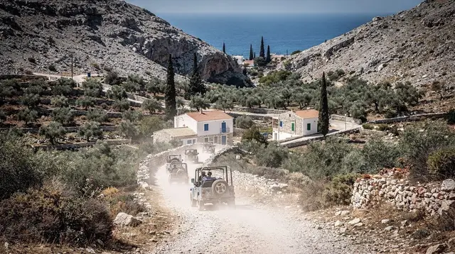
A full-day 4x4 route through the foothills below Psiloritis and the Lasithi plateau covers terrain a scenic flight would only glimpse from altitude, with stops at viewpoints a flight cannot offer. a full-day Land Rover tour through the Cretan hill country is built around exactly that kind of ground-level access to the high interior. A faster, rougher alternative covers similar terrain on two smaller wheels: a quad safari through Crete’s back-country tracks gets closer to the rock and scrub than any flight would.
For the most direct way to feel the scale of the drop from ridge to sea that a flight shows from above, walking into it beats flying over it. a guided hike down the Samaria gorge descends 16 km from the Xyloskalo at Omalos, at 1,227 m, through the Lefka Ori to the coast at Agia Roumeli, following the same fold in the mountains that a paragliding launch above Chania would show from the air. The full route, its one-way structure and the boat exit that follows are covered in the Samaria gorge complete guide.
At the end of a day spent chasing views, whether airborne or not, a sunset safari across the western hill country gives the same ridge-to-sea contrast in its softest light, as the sun drops behind the Lefka Ori and the White Mountains turn from grey to gold.
Practical notes before booking anything airborne
A few points are worth carrying into any booking decision, air-based or not. First, weather windows in Crete are real but not exact: the late-April-to-June and September-to-mid-October ranges describe a pattern across many years, not a forecast for a specific week. Second, no scenic flight or paragliding operator can be named here as fixed or permanent, since small aviation and adventure-sport businesses on the island change from season to season; the air adventures category page is the place to check what is currently bookable rather than relying on any single mention.
Third, the altitude figures above, Psiloritis at 2,456 m, Pachnes at 2,453 m and the Dikti at 2,148 m, are fixed and worth remembering regardless of which activity gets booked, since they explain almost everything else about the island’s relief: why snow lingers into early summer, why there is no lift to any of the three, and why the drop to the coast is the single most striking thing to see, on foot, on a wing, or from a seat at altitude.
Scenic flights and paragliding in Crete: your questions answered
Is there a cable car or chairlift up into these mountains?
No. Despite snow lingering on Psiloritis, the Lefka Ori and the Dikti into May or June some years, Crete has no cable car and no ski lift anywhere on the island. The only ways up are on foot, by 4x4 track where one exists, or in the air.
Which airport should I use for a paragliding or scenic-flight trip?
Heraklion (HER) and Chania (CHQ), at Souda, are the two main gateways and both sit close to their respective mountain backdrops. The small Sitia (JSH) airport serves the far east. Kastelli, a new airport near the north coast, is still under construction and not open to traffic, so it is not an option today.
When is the best time to fly over Crete?
Late April to June and September to mid-October give the steadiest conditions: the gorges and mountain routes are open, the heat has not peaked, and the meltemi wind has not set in. July and August bring the strongest and most frequent meltemi days, which can ground flights with no notice.
Does the meltemi cancel paragliding and scenic flights?
It can. The meltemi is a strong, sustained north wind that peaks in July and August and is already known for cancelling boat trips to Balos, Gramvousa and Chrissi. The same wind pattern affects any flight that depends on calm air, so a booking in high summer carries a higher chance of a no-fly day than one in late spring or autumn.
How high are the mountains you fly past or over?
Psiloritis, also called Mount Ida, is the island’s high point at 2,456 m. Pachnes, the highest summit of the Lefka Ori or White Mountains, reaches 2,453 m. The Dikti range above the Lasithi plateau tops out at 2,148 m. All three can hold snow into May or, in a heavy year, June.
Is a scenic flight and a tandem paragliding flight the same thing?
No. A tandem paragliding flight is a short, wind-launched glide with an instructor, typically off a coastal or hillside launch point, and it depends on the day’s wind. A scenic flight in a small aircraft is a different kind of trip with its own aircraft, route and operator; this guide does not assume one specific product exists at any given time, since availability changes.
Can I book a specific viewpoint or guaranteed visibility?
No operator can promise a clear view of Psiloritis or the Lefka Ori on a given day, and this guide does not carry a weather or visibility guarantee for any activity. Haze, cloud on the peaks and wind all vary by season and by the hour, which is exactly why the shoulder-season windows above matter more than the calendar date alone.
Air Adventures in Crete on GetYourGuide
Verified deep-linked GetYourGuide tours. Book through these links and we earn a small commission at no cost to you.
GetYourGuide does not provide a product photo for this activity — the image shows the meeting point, photographed by us.