Psiloritis Summit Hike: How Long It Really Takes
How long does it take to climb Psiloritis, Crete's highest peak?
Budget a full day, roughly 6 to 8 hours of walking from the Fournoti / Toichos trailhead above Anogia, plus the drive there and back. That assumes dry, snow-free ground; in May and often into June, snowfields on the upper slopes slow the pace further and can turn the ascent back altogether.
Crete’s Actual High Point
Ask most first-time visitors which mountain is the highest in Crete and they will guess wrong. The rugged skyline that dominates photographs of the south-west, the Lefka Ori or White Mountains, tops out at Pachnes, 2,453m. Psiloritis, also known as Mount Ida, sits further east above the village of Anogia and reaches 2,456m — three metres higher, enough to make it, officially, the roof of the island. Dikti, the mountain that shelters the Lasithi plateau and the Dikteon cave in the east, is lower again at 2,148m.
That three-metre margin over Pachnes is not the point of this page. The point is that neither figure tells you what a day on the mountain will actually cost you in hours, legs and judgement, and most sources that quote “2,456m” stop right there, as if height were the only variable. It is not. Snow, route-finding and the absence of any infrastructure matter more to your day than the number on the summit cairn.
The number that actually decides your day: snow
Psiloritis is a limestone massif, and limestone holds snow in its gullies and north-facing hollows long after the lowland beaches have warmed up. Snow accumulates from around December and, in a normal year, does not fully clear from the upper mountain until May. In a heavier winter, patches survive into June. This is consistent with the island-wide pattern described in when to visit Crete: the whole of Crete runs on a May-to-October hiking season, and Psiloritis is simply the place where that rule bites hardest, because altitude adds its own calendar on top of the coastal one.
What this means in practice: an ascent attempted in April, or even in the first half of May, can mean walking on snow for the final few hundred metres of height gain, with all the extra time, extra caution and extra equipment that implies. A trekking pole is not enough on hard spring snow; some parties carry microspikes for exactly this stretch.
Cloud forms quickly around the summit ridge even once the snow itself has gone, and a whiteout on unmarked limestone is a genuinely disorientating problem, not an inconvenience. Anyone comparing this hike to the gorge walks lower down the island, where the worry is heat and water, needs to reset expectations: on Psiloritis in spring, cold, wind and snow are the operative hazards, not sunstroke.
How long the climb actually takes
Here is the honest range, and why it is a range rather than a single number.
| Season | Trail condition | Realistic walking time (round trip) |
|---|---|---|
| Late June to September | Dry, rocky, some scree | 6-8 hours |
| May to mid-June | Patchy snow on upper slopes | 8-10 hours, weather-dependent |
| April and earlier | Continuous snow above ~2,000m | Not a normal hiking outing; near-winter conditions |
| October | Dry but shortening daylight, first storms possible | 6-8 hours, start early |
These figures are for the standard route from a trailhead near Anogia, at roughly 1,400-1,500m, up onto the ridge and along to the summit and back. They assume a reasonably fit party in daylight, not a trail run and not a rescue-team benchmark. Add the drive from wherever you are staying, and a full Psiloritis day realistically starts before 7am and finishes after dark falls in shoulder season, when daylight is shorter. This is not a hike you fit in as a half-day extra alongside a beach morning.
For comparison, a Samaria gorge walk is a similar physical effort in total hours but on a defined, one-way, downhill-dominant path with checkpoints and rangers. Psiloritis has none of that. There is no park gate, no ranger station, no fixed closing time, and — this matters — no one checking that you came back down.
No lift, no exception
It bears repeating because visitors from Alpine countries sometimes assume otherwise: there is no cable car, chairlift, gondola or any other mechanical assistance on Psiloritis, or anywhere in Crete. The snow that sits on the summit into late spring might suggest a ski resort infrastructure somewhere nearby. There is none — no lift, no piste, no groomed run. Every metre of height on this mountain, winter or summer, is earned on foot. Drivers occasionally ask about a road to the top; the road stops well below the ridge, at a trailhead, and from there it is a walking-only mountain, the same as Pachnes and Dikti.
Getting to the trailhead
A rental car is not optional here; it is the only practical way in. See renting a car in Crete and driving in Crete for the general rules, but the specific point for Psiloritis is this: the access road climbs from Anogia through increasingly bare, high-altitude terrain, narrows, and in winter or early spring can itself be snow-covered or gated shut.
Check locally in Anogia before driving up — a taverna or the village itself is the reliable source, not an app. Anogia is the base almost everyone uses: it sits at around 740m, already well above the coast, with rooms, food and fuel, and is the last proper village before the mountain track. From Anogia, the drive to the usual trailhead near Fournoti or the Toichos takes roughly 30-45 minutes on a rough but passable road in dry conditions.
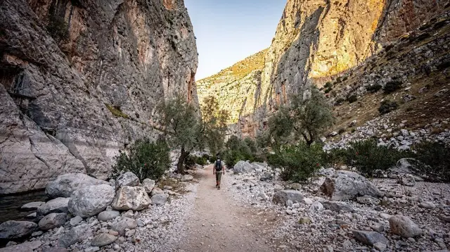
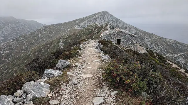
The route from there joins the long-distance E4 path for part of its length; see the E4 trail across Crete for how this one massif connects into the island’s longer walking network. That connection is useful context, not a substitute for local knowledge: the E4 across Psiloritis is not painted with the dense, reassuring waymarking you would find on a well-funded Alpine long-distance trail. Cairns mark parts of the route; other stretches are simply the path worn by feet and goats across open limestone, which is easy to lose in poor visibility.
a guided ascent of Psiloritis with a local mountain leader removes most of the route-finding risk and is the option worth taking seriously if this is your first Cretan mountain day, or if you are visiting in the shoulder months when snow is still likely.
What the route actually asks of you
This is not a graded, engineered trail. Expect:
- Loose limestone scree on the steeper sections, which is slow and awkward underfoot in both directions.
- Long stretches with no shade and no water source once you leave the treeline — carry everything you will drink.
- A summit ridge exposed to wind from several directions; even a calm morning at the trailhead can mean a cold, gusty ridge two hours later.
- Weather that changes fast: cloud can roll in over the ridge within thirty minutes, cutting visibility to a few metres.
- No mobile signal for long stretches of the upper mountain.
None of this is a reason to avoid the mountain. It is a reason to plan the day the way you would plan any serious mountain hike anywhere else in Europe: an early start, full water, warm layers even in July, a paper map or downloaded offline route in addition to a phone, and a realistic honest look at the weather forecast that morning rather than the forecast for the coast. See mistakes to avoid in Crete and safety and health in Crete for the island-wide version of this advice; Psiloritis is simply where the stakes of ignoring it are highest.
When to actually go
| Window | Verdict for a summit attempt |
|---|---|
| June to September | Best odds of dry ground; go early to beat afternoon heat and cloud build-up |
| May | Possible but snow-dependent; ask locally in Anogia before committing |
| October | Good, dry, cooler; days shorten, so start earlier |
| November to April | Winter mountain conditions; not a standard hiking outing |
This lines up with the island’s general season described in Crete weather month by month, Crete in May and Crete in June — but Psiloritis lags the coast by several weeks because of altitude. A beach day in Rethymno or Chania in early May tells you almost nothing about whether the Psiloritis ridge is walkable that week.
If you don’t want the full summit
Not every visitor to this massif wants an 8-hour mountain day, and the area rewards a shorter visit too. Anogia itself is worth an afternoon: it is tied closely to Cretan music through the lyra player Nikos Xylouris, was rebuilt after being destroyed during the Battle of Crete, and has a strong weaving and craft tradition worth seeing in Anogia and Mount Psiloritis and in the activities listed at things to do around Anogia and Psiloritis.
Nearby, the Sfendoni cave offers a dramatic underground alternative to a mountain day, and the Melidoni cave adds a grim, well-documented piece of wartime history a short drive away. The pottery village of Margarites, on the lower slopes toward Rethymno, is a gentler way to spend an afternoon in the same mountain range without the altitude.
A private jeep tour up onto the Psiloritis slopes and a mountain chalet is a realistic middle option: you get onto the massif, see the terrain the hikers cover, and reach altitude and views without committing to the full walking day. For a broader taste of what the mountain and its villages hold, including the cave and local cheese-making traditions, a Sfendoni cave and Anogia cheese-making tour by minivan covers the cultural side of the massif in half the time.
For hikers who want mountains without Psiloritis’s specific snow calendar, Pachnes and the White Mountains is the equivalent long day in the west, and the Lasithi plateau day loop under Dikti is a gentler, lower-altitude walking day in the east. Anyone planning a whole trip around mountain days rather than a single ascent should look at Crete hiking week or white mountains and Sfakia in three days for how to sequence them against the coast.
Packing for a mountain that can hold two seasons in one day
Coastal Crete and the Psiloritis ridge are, weather-wise, close to two different countries on the same day in shoulder season. The general list in what to pack for Crete covers beach and town needs; for this hike, add a warm layer, a windproof shell, gloves if you are going in May or June, and sturdy boots rather than trail shoes — loose scree and residual snow both punish light footwear. Sunscreen still matters even with snow on the ground; reflected glare at altitude is easy to underestimate. If cloud or wind is forecast on the ridge, treat that forecast as the deciding factor over any plan made from the coast the night before.
The bottom line
Psiloritis at 2,456m is Crete’s highest point by a narrow margin over Pachnes, and that number is the least useful fact about planning the climb. What actually decides your day is the season: snow lingers into May, sometimes June, there is no lift or mechanical shortcut anywhere on the island, and the route above Anogia is a real mountain path, not a manicured trail. Treat it as a full, serious hiking day with an early start, proper gear and a live weather check, or hand the route-finding to a guide and enjoy the massif’s villages, caves and viewpoints instead.
Frequently asked questions about the Psiloritis summit hike
How high is Psiloritis (Mount Ida) and is it really the highest point in Crete?
Psiloritis, also called Mount Ida, reaches 2,456m, making it the highest point on Crete. It edges out Pachnes at 2,453m in the Lefka Ori (White Mountains) and stands well above Dikti at 2,148m in the east.
Is there a cable car or chairlift up Psiloritis?
No. There is no cable car, chairlift or any mechanical lift anywhere in Crete, on Psiloritis or elsewhere, despite the snow that covers the summit for much of the year. Every metre of ascent is on foot.
When does the snow clear from Psiloritis?
Snow typically lingers on the upper slopes into May, and patches can persist into June in a heavy year. A serious summit attempt belongs in the same May-to-October window as the rest of the island’s hiking season, and even then the first weeks can still mean snow crossings.
Do I need a guide to climb Psiloritis?
It is not required, but the upper mountain has no continuous waymarked trail in the sense of a European long-distance route, and paths braid, fade on rock and scree, and can be obscured by snow or cloud. A local guide is the safer and, for most visitors, the sensible choice.
Can I drive to the summit of Psiloritis?
No. A rental car will get you to Anogia and on to the trailhead near the Fournoti / Toichos area at around 1,500m, but the final roughly 900m of ascent to the 2,456m summit is on foot only.
Is the Psiloritis hike suitable for beginners?
Not as a first mountain hike. It is a long, high-altitude walk over rough limestone terrain with route-finding, weather that turns quickly, and, for much of the season, snow. Treat it as a serious mountain day, not a casual walk.
Where do people usually start the hike from?
Most ascents start from Anogia, on the north side of the massif, driving up to a trailhead near the Toichos or the Prinos area, close to the E4 European long-distance path and mountain refuges used by local clubs.
What else is there to do around Psiloritis if I don’t want to summit?
Anogia itself, the Nikos Xylouris connection, the Sfendoni cave nearby, and shorter walks onto the lower slopes all let you experience the mountain without the full ascent. Jeep and 4x4 tours reach viewpoints and villages on the massif’s flanks.
Hiking Tours in Crete on GetYourGuide
Verified deep-linked GetYourGuide tours. Book through these links and we earn a small commission at no cost to you.
GetYourGuide does not provide a product photo for this activity — the image shows the meeting point, photographed by us.