Richtis Gorge and Its Waterfall: Crete's Quiet Far-East Hike
Is the Richtis Gorge hike worth it if I'm already doing Samaria?
Yes, for a different reason. Richtis is a short, shaded, watermill-and-waterfall walk down to a cove in Crete's far east, near Sitia, not a rival to Samaria's scale in the Lefka Ori. It belongs to an east-Crete itinerary, not a detour from a west-coast base.
Why Choose Richtis Over a Gorge Out West
Most visitors who plan a gorge walk in Crete are thinking of one place: the Samaria gorge, cut through the Lefka Ori in the island’s south-west. It is the gorge that gets photographed, the one every hotel desk in Chania and Rethymno can book you onto by nine in the morning. The Richtis gorge is not that hike, and it is not trying to be. It sits at the opposite end of the island, in the far east near Sitia and Vai, a short, shaded, waterfall-and-watermill walk that belongs to a completely different part of a trip.
That distance is the point. Crete runs about 260 km from Kissamos in the west to Zakros in the east, and no single base covers it. If your itinerary is built around Chania, Rethymno or even Heraklion, Richtis is not a side trip — it is hours away, on the far side of the Lasithi plateau and the mountains behind Agios Nikolaos. It belongs to a trip that actually spends a night or two around Sitia, Ierapetra or Agios Nikolaos, not to a day pencilled in from a west-coast hotel.
What you get in exchange for that drive is a walk that behaves nothing like Samaria. There is no 16 km one-way descent, no boat required to leave, no gates that shut in the early afternoon. Richtis is a modest streambed hike, roughly two to two and a half kilometres down through a string of ruined watermills to a small waterfall and a quiet pebble cove on the north coast. It suits a morning, not a full day, and it rewards people who want a gentler, greener, far less crowded version of a Cretan gorge — with the honest trade-off that it takes real effort to get there in the first place.
Where Richtis Gorge Actually Is
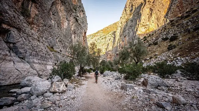
The trailhead sits above the villages of Exo Mouliana and Kalavros, inland from the north coast road between Sitia and the port of Palaikastro. From there the path follows a seasonal stream down through a narrow, tree-shaded ravine, passing the crumbling stone shells of old watermills that once used the same water. The gorge opens out near its end at a small waterfall and pool, then continues a short distance to Richtis beach, a quiet pebble cove reached by no road of its own.
This is genuinely rural Crete. The nearest towns of any size are Sitia, about half an hour’s drive away, and Ierapetra further south. The famous palm beach at Vai and the fortified monastery of Toplou are both within easy reach on the same roads, which is why most visitors who make the trip to Richtis fold it into a day that also covers one or both of those. The Minoan palace site at Zakros, at the very tip of the island, is a further drive east again — a reminder of just how much ground this corner of Crete covers on its own.
Getting There: Why the Car Is Not Optional
Crete has no railway and no cable lift anywhere on the island, a fact that surprises some first-time visitors used to mountain regions elsewhere in Europe. The KTEL coach network is a real option along the north coast’s main highway, linking Chania, Rethymno, Heraklion and Agios Nikolaos at a reasonable frequency. East and south of that spine, service drops off fast, and the villages above Sitia that lead to Richtis are not on any useful coach route.
In practice, a rental car is how almost everyone reaches this trailhead. If you would rather not drive yourself out to a rural gorge, the more comfortable route is a private day trip that links Sitia, Vai and Toplou monastery in one route, which covers the same far-east corner of the island without you having to navigate unfamiliar village roads.
The roads themselves are typical of rural Crete: narrow, winding through olive groves and past the odd flock of sheep, with blind bends on the descent into the villages. Cretan drivers have a standard courtesy on roads like this — pulling briefly onto the hard shoulder to let a faster car pass — and it is worth knowing that convention before you arrive, both to use it yourself and to recognise it for what it is. It is a local courtesy, not an invitation to overtake blind on a bend you cannot see through. Treat it the same way on the approach to Richtis as you would on any of the island’s mountain roads.
The Hike: What the Trail Is Really Like
The walk down from the trailhead near Exo Mouliana follows the line of the stream, dropping through a ravine shaded for most of its length by plane trees and oleander. Stone paths and simple wooden footbridges carry the route across the water several times, and the ruined watermills along the way are the closest thing this gorge has to a monument — roofless stone buildings that once ground the grain of the villages above, left to the ferns and the running water.
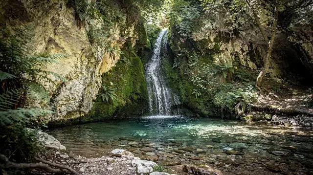
Near the bottom, the stream gathers into a pool below a modest waterfall, a natural stopping point before the last stretch down to the sea. The gorge opens onto Richtis beach, a pebble cove with no road access of its own, reached only on foot from the gorge or by boat. It is a genuinely quiet spot outside the busiest weeks of summer, and swimming in the cove after the walk down is, for most visitors, the actual highlight of the day.
Coming back up is the part that catches people out. The descent takes most walkers around ninety minutes at an easy pace; the return climb takes longer and is noticeably harder in the heat of a summer afternoon, since much of the upper trail loses its shade once you climb above the streambed. Some walkers avoid the climb altogether by arranging transport at each end and treating Richtis as a one-way, downhill walk to the beach — worth planning ahead if you would rather not retrace your steps uphill in the midday sun.
Snakes, Heat and Other Worries You Can Set Aside
One concern that visitors bring to any Cretan gorge does not need to travel with you to Richtis: dangerous snakes. Crete has four snake species and none of them are vipers — there is no equivalent here of the venomous snakes found on the Greek mainland. It is a genuine reassurance, not a rounding-down of the risk, and it applies just as much on a quiet path like this one as it does on Samaria.
The hazards that do apply are the ordinary ones of a Mediterranean streambed walk: loose or wet stones on the descent near the watermills, a stream that can rise quickly after heavy rain, and the sun and heat on the exposed sections of trail, especially on the climb back up. Good shoes with grip, a hat, and more water than feels necessary are the practical basics — there is no kiosk or taverna at the trailhead to buy more once you have started.
Richtis Compared with the Gorges and Beaches Everyone Has Heard Of
It is worth being direct about what Richtis is not, so the comparison does not disappoint anyone who arrives expecting something else. It is not Samaria: there is no 16 km descent from the Xyloskalo, no exit by boat, no closed season and reopening each spring, and nothing like the same scale of walls or the same volume of hikers moving through it in July and August. The Samaria gorge remains the island’s signature hike, and Richtis was never built, by nature or by tourism, to compete with it.
It is also not a match, in visitor numbers, for the west coast’s best-known natural sights. Balos lagoon and Elafonissi beach pull heavy day-trip traffic from Chania and the resorts along the north-west coast, arriving by boat and by coach in numbers Richtis never sees. That gap is really a gap in geography rather than in quality: those places sit within striking distance of the island’s busiest tourist bases, and Richtis, in the far east near Sitia and Vai, simply does not.
What Richtis offers instead is closer in spirit to the Imbros gorge near Sfakia — a shorter, gentler, genuinely local walk rather than a headline attraction — transplanted to the opposite end of the island. If your trip already has room for one big-name gorge day in the west, Richtis is not a reason to skip it. It is a reason to build one quiet morning into an east-Crete itinerary that would otherwise be all beaches and ruins.
Best Time to Go
Spring, from April through June, is when Richtis looks its best: the stream runs fullest, the gorge is green, and wildflowers line the upper trail. Early starts matter more from July through September, when the shaded lower gorge stays pleasant but the open trailhead and the uphill return can get uncomfortably hot by late morning — arriving by eight or nine and being back at the car before the worst of the midday heat is the sensible pattern in high summer.
Unlike Samaria, which shuts for the winter months on safety grounds, Richtis is a short enough walk to stay generally accessible outside the main season, weather permitting. Autumn, from September into October, can also be a good window, with the stream refreshed by the first rains and far fewer people on the path than in August.
Pairing Richtis with Sitia, Vai and the Far East
Richtis makes the most sense as part of a day, or a short base, built around Crete’s easternmost corner rather than as an isolated stop. Sitia itself, an easygoing port town with none of the resort feel of the north-central coast, is the natural overnight base, and the fortified Toplou monastery and the palm-fringed beach at Vai sit on the same short stretch of road.
Visitors who would rather see all three without renting a car themselves can book a direct transfer from Heraklion to Vai’s palm beach or a private tour and wine tasting at Toplou monastery as a way of covering the wider area.
Further afield, the Minoan palace ruins at Zakros mark the true end of the island, an hour or so beyond Sitia through empty countryside — a further sign of how much road this part of Crete demands. Inland, the Lasithi plateau day loop and the Dikteon cave are within reach if your east-Crete stay runs to several days rather than one.
None of this is a criticism of the drive; it is simply what an island 260 km long asks of anyone who wants to see more than one of its corners, and it is the same logic that keeps a comparison of east and west Crete worth reading before you plan the rest of the trip.
Tours and Day Trips If You’d Rather Not Drive Yourself
Renting a car remains the most flexible way to combine Richtis with a longer loop of Sitia and Vai, since it lets you set your own pace on the descent and the climb back up. For visitors who prefer not to navigate the village roads themselves, or who are based further from the east and want the whole area handled in one outing, a private day trip that links Sitia, Vai and Toplou monastery in one route is the closest match to this guide’s itinerary, with a driver who already knows the roads and the parking at each stop.
Two other bookable options round out a stay in this part of the island without needing your own car. An olive grove visit and oil tasting near Sitia fills an easy afternoon around the gorge walk, and further west toward Ierapetra, a guided trek through the Sarakina gorge near Myrtos beach is a sensible pairing for visitors who want a second, different gorge walk without driving all the way back to the west of the island.
Practical Planning Notes
| What | Detail |
|---|---|
| Trailhead | Near Exo Mouliana, above Kalavros, inland from the Sitia-Palaikastro road |
| Distance | Roughly 2-2.5 km one way to Richtis beach |
| Time | About 1.5 hours down; longer, and hotter, back up |
| Difficulty | Easy to moderate; shaded streambed path, some loose stone |
| Water | None sold at the trailhead — bring more than you think you need |
| Season | Best April-June and September-October; walkable outside high summer |
| Nearest town | Sitia, about 30 minutes by car |
| Best paired with | Vai beach, Toplou monastery, Zakros |
Bring proper walking shoes rather than beach sandals, a hat and sun protection for the exposed sections, and a swimsuit for the pool near the waterfall or the cove at the bottom. Mobile signal thins out in the ravine itself, so tell someone your plan if you are walking alone, and check locally after any recent heavy rain, since a swollen stream can make the crossings slippery. For the wider logistics of a rental car in this part of the island, see the guides on driving in Crete and renting a car in Crete; for the coach network’s real limits east of the main highway, see KTEL buses in Crete.
Richtis Gorge and Waterfall Hike: Your Questions Answered
How long is the Richtis Gorge hike and how hard is it?
The walk down from the trailhead near Exo Mouliana to Richtis beach is roughly two to two and a half kilometres one way, on a shaded path with stone steps and stream crossings, taking most walkers around an hour and a half down. It is an easy to moderate hike by Cretan standards, with nothing like the exposure or scale of the Samaria gorge, but the return climb in midday heat is the part people underestimate.
Where does the Richtis Gorge trail start and end?
The usual route starts near the village of Exo Mouliana, above Kalavros, and follows the streambed down past a string of ruined watermills to a small waterfall and then the pebble cove of Richtis beach, on the north coast east of Sitia. Some walkers arrange a car or taxi at each end and walk one way rather than climbing back up.
Do I need a car to reach Richtis Gorge?
Effectively yes. There is no train and no cable lift anywhere on Crete, and the KTEL coach network that works well along the north coast between Chania and Agios Nikolaos thins out badly east of Sitia. A rental car, or a booked driver, is the practical way to reach the trailhead and to link it with Vai or Toplou on the same day.
Is Richtis Gorge as crowded as Samaria, or as famous as Balos and Elafonissi?
No, and it is worth setting that expectation before you go. Samaria, Balos and Elafonissi sit in western Crete and draw the bulk of the island’s organised-tour traffic; Richtis is a rural, lightly signed trail in the Sitia-Vai area that most western-based visitors never reach. Expect a handful of other hikers on a summer morning, not a queue.
Are there snakes or other dangers on the trail?
Crete has no dangerous snakes — four species live on the island and none are vipers, so this is one worry you can set aside. The real hazards on Richtis are ordinary hiking ones: loose stones on the descent, a hot climb back up without enough water, and a streambed that can run high after rain.
When is the best time to hike Richtis Gorge?
Spring, from April through June, brings the fullest waterfall and the greenest gorge, with wildflowers along the path. Early morning starts are best from July through September, when the shaded lower gorge stays cool but the open trailhead and the climb back up get hot by midday. The path is walkable outside high summer too, unlike Samaria, which closes for the winter.
Can I combine Richtis Gorge with Vai beach or Sitia in one day?
Yes, and it is the natural pairing. Richtis, Vai’s palm beach and the town of Sitia all sit within a short drive of each other in the island’s far-east corner, and Toplou monastery is on the same road. A single day based in or near Sitia can cover the gorge in the morning and Vai or Toplou in the afternoon without much driving.
Is the waterfall at Richtis flowing all year?
It runs strongest after the winter and spring rains and through early summer, feeding a pool near the old watermills before the stream reaches the sea at Richtis beach. Like most seasonal streams on Crete, it thins by late summer in a dry year, so a spring or early-summer visit gives the most reliable flow.
Gorge Hikes in Crete on GetYourGuide
Verified deep-linked GetYourGuide tours. Book through these links and we earn a small commission at no cost to you.
GetYourGuide does not provide a product photo for this activity — the image shows the meeting point, photographed by us.